Mathematical Approaches to Stop Gerrymandering
Gerrymandering is the act of changing the boundaries of election regions to try to affect the vote. This appears to be one of the unavoidable aspects that comes with having regions as part of an election system at all, given that someone has to pick the boundaries and it is the people in charge that choose where they must lie.
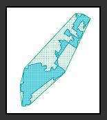
In the UK these boundary reviews come up at regular intervals and the Labour party were in charge for the last two giving them a huge advantage in future elections. The next one looks like it will be while the Conservatives are in charge (I wrote this back in May and this looks less certain now) and that will set the balance back the other way. Note that it is not the fault of the parties for taking advantage of this, it is a fault of the system as a whole. To see an example of gerrymandering gone to the extreme, here’s a map of one of the voting districts of Illinois:

This is one district
One proposal is to split the regions into equal sizes of population in a mathematical way such that the human decisions are taken out of it. You would think there would be some nice concrete way to measure whether a region was geographically sensible which would be obvious to everyone. Clearly the map above is wrong because it has lots of spindly bits rather than a nice compact (and preferably convex) area. Unfortunately there are several ways of doing this and each will give slightly different outcomes.
Let's look at two commonly used measures of compactness. First up is the Reock measure. It compares the area of the region with the area of the smallest circle which fits around the region.
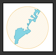
Reock
Having a long thin bit really messes you up with the Reock measure; but bulky regions come off well, even if they have frilly edges.
Second up with have one of the more popular measures, Polsby-Popper. Again it compares the area of your region with a circle, but this time the circle is the one with the same perimeter as your region.

Polsby-Popper
This time you get punished for having lots of little tweaks on your boundaries, but slightly less so for having long thin bits.
Finally, we have the Convex Hull measure. Imagine drawing straight lines around your region to form a tight fitting polygon. It is with this polygon that you compare your region's area.

Convex Hull
This means that you can have a perfectly compact region without aiming for a circle (which is a bonus because circles don't tessellate).
There is a common trope of internet articles suggesting that Gerrymandering can be solved by applying a mathematical method, but because there are so many reasonable methods, the choice is still a political choice. Instead of applying them blindly, these methods for evaluating compactness are perhaps best used to work out whether boundaries that are already being proposed by the boundary commission are at least reasonable.
To finish, here’s a link to a brilliant video by CGP Grey about Gerrymandering.